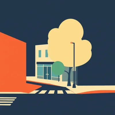
Daniel sent us this one, and I felt it in my bones. He had to run an errand in South Jerusalem — first time not taking the car in a while because it should have been quicker. What should have been a thirty-minute bus ride each way turned into a two-hour maze. Google Maps sent him to three routes that were supposed to be open but were completely blocked to pedestrians. Other walkways were technically there but actually inaccessible. His real question is: when you hit a blocked pedestrian route every three minutes over four kilometers of walking, the city stops being a city and becomes a building site with some houses in between. He's asking whether this is a coordination failure between permit authorities, and what the common reasons are that we end up with this specific kind of mess.

He's right to frame it that way. A single construction site on a walk is part of city life. But when the density of active sites exceeds the city's ability to maintain pedestrian continuity, the urban fabric fractures. You're not navigating a city anymore — you're navigating an obstacle course where the obstacles have won.
I've lived this exact scenario. The Central Bus Station to the German Colony — that's a straight shot down Jaffa Road, maybe a slight jog through the center. But right now you've got the light rail excavation eating entire blocks, a private tower foundation that's claimed the sidewalk on King George, and a water utility trench on Emek Refaim that nobody bothered to route pedestrians around. Three separate projects, three separate permit authorities, zero coordination.
Google Maps has no idea any of it exists. That's the part that makes it feel like the city is gaslighting you. The app says walk here, you get there, there's a metal fence and a hole in the ground, and your only option is to backtrack into traffic.
The paradox is almost funny if you're not the one standing next to a dumpster on a Tuesday afternoon. We want development. We want the light rail, we want housing, we want functioning water pipes. But when every block has a construction site, the city stops being a city. It becomes a building site with some houses in between — that's exactly Daniel's phrase, and it's the right one.
That's what I'd call the failure mode here. Not construction itself — construction is how cities stay alive. The failure pattern is when the cumulative pedestrian impact of all active projects exceeds what the street network can absorb, and nobody is measuring that threshold.
Where do we even start diagnosing this? Because I refuse to believe it's just inevitable. Tokyo builds constantly and you can still walk there without feeling like you're in a demolition derby.
That's exactly the right question, and it's what we should dig into. Is this an unavoidable cost of growth, or is it a specific coordination failure that can be fixed by changing how permits are issued and tracked?
To answer that, we need to understand what cities actually measure — and what they don't. Every city with a traffic engineering department tracks something called vehicle level of service. It's a grade, A through F, that tells you how smoothly cars are moving through an intersection or a corridor. If it drops below a certain threshold, planners adjust signal timing, add turn lanes, widen roads. There's an entire profession built around keeping that grade up.
There is a concept called pedestrian level of service — it exists in the academic literature, it's been around since the nineties — but virtually no city tracks it operationally. They don't measure what you'd call walkability impedance: how much friction a pedestrian encounters trying to move through the network. Detours, blocked sidewalks, missing crossings, construction barriers. None of it gets aggregated into a metric that triggers action.
The thing that tells you whether your city is actually navigable on foot — the thing Daniel spent two hours discovering the hard way — doesn't have a dashboard. But the car traffic on those same streets is being monitored in real time.
That's the metric gap, and it's the root cause of everything we're about to unpack. If nobody is measuring pedestrian network continuity, then nobody is responsible for maintaining it. Each permit authority can honestly say they reviewed their own project's impact and found it acceptable — because they're only looking at their one hole in the ground. Nobody is adding them up.
It's like a bank that tracks every individual withdrawal but never checks the account balance. Each transaction looks fine on its own, and then suddenly you're overdrawn and standing in front of a metal fence on King George Street.
And the threshold Daniel described — one blocked route every three minutes over four kilometers — that's not just annoying. That's the pedestrian network functionally broken. At that density of obstruction, the city is no longer providing a continuous walking surface. It's providing fragments.
Which brings us back to the central question. Is this just what growth looks like, or is it a coordination failure we can actually fix?
I'd argue it's almost entirely a coordination failure, and we can see that by looking at cities that have solved it. But first we have to understand what's breaking. And that means looking at how permits actually work — or more precisely, how they don't work together.
Let's go there. Walk me through the institutional plumbing.
Picture the permit process for a single block in central Jerusalem. The light rail authority gets its corridor permit from the Ministry of Transport — that's a national body. The private developer building a residential tower pulls a building permit from the municipal planning committee. The water company trenches the street under a utility permit from the infrastructure department. And if a contractor needs to occupy the sidewalk for staging, that's a separate right-of-way occupancy permit from yet another desk.
Four different authorities, four different application processes, four different sets of review criteria. And none of them are required to check what the other three have already approved on the same stretch of pavement.
That's permit fragmentation, and it's the primary institutional failure here. Each department is doing its job as defined — the transport authority cares about the rail alignment, the planning committee cares about building code compliance, the utility department cares about pipe specifications. Pedestrian continuity is nobody's job description.
Each project gets a green light in isolation, and the cumulative effect is Daniel's two-hour maze. The system is designed to review projects, not places.
And it gets worse when you add the incentives. A developer's costs are dominated by financing — every day of delay is interest payments. A utility company faces political pressure to finish road work before complaints peak. Every actor is optimizing for their own timeline, which means maximizing their footprint to work faster. Blocking an extra fifty meters of sidewalk to stage materials makes the project cheaper and quicker. The cost of that blockage is borne entirely by pedestrians — it's a classic externality.
The tragedy of the commons, but the commons is the sidewalk and the goats are backhoes.
That's the image. And in most cities, there is literally no single office that can see all active sidewalk obstructions at once. No map, no database, no person whose phone rings when three consecutive blocks go dark to pedestrians. The data exists — every permit includes a site plan showing the footprint — but it lives in separate filing systems that don't talk to each other.
That's almost worse than not having the data. The information is there, it's just organized in a way that makes it useless for the one question Daniel needed answered: can I walk from here to there?
Which brings us to what I'd call the unowned metric. Cities have an entire profession built around vehicle level of service — that A through F grade I mentioned. If an intersection drops to a D, traffic engineers are in meetings about it. But the maximum uninterrupted walking distance in a city? Nobody owns that number. There's no threshold where someone says, pedestrians are encountering a blocked route every three minutes, we need to intervene.
Without that metric, there's no trigger for coordination. Each permit reviewer can honestly say they looked at their project and found the pedestrian impact acceptable — because acceptable is undefined. There's no standard to violate.
Now contrast this with London's Street Works permit system. Under the Traffic Management Act, any utility or contractor that wants to dig up a street applies through a single coordinated system. They have to specify the exact duration and area of occupation, and they pay charges based on both — the longer and larger the footprint, the higher the fee. If two utilities need the same stretch, the system forces them to coordinate schedules so the street isn't opened twice.
The financial incentive flips. Instead of maximizing your footprint to finish faster, you minimize it to reduce fees. The externality gets priced back in.
London's system is enforced. Inspectors can issue fixed penalty notices for overstaying a permit or occupying more space than approved. The data is public — Transport for London publishes a real-time map of every active street works permit, so navigation apps can actually route around closures. That's the pedestrian data layer we were missing.
Meanwhile in Jerusalem, the light rail corridor has been a multi-year pedestrian disruption, and simultaneous private towers went up along the same route, and those permits never had to acknowledge each other's existence.
New York City offers a different piece of the solution. The Department of Transportation runs something called the Pedestrian Ramp program — when construction occupies a sidewalk, the contractor is required to provide a protected pedestrian walkway, typically a covered ramp in the parking lane, with barriers separating people from traffic. DOT inspectors can show up unannounced, and they have the authority to issue stop-work orders if the pedestrian route is unsafe or missing.
It's not just coordination of permits — it's enforcement with teeth. Someone whose job is to walk the site and ask, can a person actually get through here?
That's the piece that makes the system real. Permits are paper. Inspectors with stop-work authority change behavior. In London, the financial penalty hits the balance sheet. In New York, the threat of halting work hits the schedule. Both create a reason to care about something that was previously cost-free to ignore.
What strikes me is that none of this requires some futuristic smart-city technology. It's a database, a map, and a person with a clipboard. The tools exist. The missing piece is the institutional will to say pedestrian continuity is a service the city is obligated to provide, not a nice-to-have that disappears the moment a backhoe shows up.
We've got this institutional failure. But the costs don't stop at frustration — they ripple through the whole urban system. When walking becomes unreliable, people default to cars even for short trips. That blocked sidewalk on Jaffa Road doesn't just inconvenience the pedestrian — it puts them onto a bus that's now stuck in traffic, or into a car they wouldn't have taken otherwise. The congestion compounds.
That's the irony that should make planners lose sleep. The construction is supposed to enable density — the light rail, the new housing, the walkable city of the future. But during the construction phase, it's actively undermining the very density it's building toward. You're making the city impossible to walk in, so people drive, so traffic gets worse, so the political pressure to prioritize cars gets stronger.
There's an equity dimension here that doesn't get enough attention either. Think about who bears the cost of this failure pattern. If you own a car, a blocked sidewalk is an annoyance — you drive instead. If you don't own a car, it's not an annoyance, it's a barrier. Lower-income residents, elderly people, children walking to school — they don't have the option to just switch modes. They're the ones doing the two-hour maze while everyone else complains about traffic from inside an air-conditioned vehicle.
In Jerusalem specifically, the neighborhoods with lower car ownership — and those tend to be the ones Daniel was walking through — see the most severe sidewalk blockages. The people least able to absorb the disruption are getting the highest dose of it.
That's not a coincidence. Those neighborhoods also tend to have less political clout to demand enforcement. A blocked sidewalk in Rehavia gets a call to the mayor's office. A blocked sidewalk in a working-class neighborhood gets a shrug.
The failure pattern isn't just about coordination — it's regressive. The city, during construction, effectively locks out the people who need walkability most.
Which is why we need to start thinking about construction phasing as urban design, not as a temporary nuisance. Tokyo is the best example of this. Walk past any construction site in central Tokyo and you'll find a covered pedestrian walkway — roofed, lit at night, with clear signage showing exactly where you're being routed. It's not an afterthought. It's standard practice, required by regulation, and it's treated as part of the construction budget from day one.
The mindset shift is the key. Most cities treat the construction period as an interruption — something to endure until the real city comes back. Tokyo treats it as a phase of the city that deserves its own infrastructure. The temporary walkway isn't a concession, it's a design deliverable.
Pedestrians know they can still get through. Businesses along the route don't lose foot traffic. The city keeps functioning. The construction happens, but it doesn't colonize the entire public realm.
What does the path forward actually look like? We've got London's coordination model, New York's enforcement model, Tokyo's design standards. Are there cities that are pulling all of this together digitally?
Boston is doing something interesting. The city launched a platform called BuildBoston — it's a public-facing portal that maps every active construction permit in real time. You can see what's happening on any block, who's doing it, and how long it's scheduled to last. It doesn't yet feed into pedestrian navigation apps, but the data layer exists. That's the foundation.
Once you have that data layer, you can do dynamic pedestrian rerouting. Google Maps and Waze already reroute cars around construction. The reason they can't do it for pedestrians isn't a technical limitation — it's that nobody is feeding them the data in a structured format.
The missing piece is the pedestrian impact assessment. We require environmental impact assessments for major projects — why not require a pedestrian impact statement? Show us how you're maintaining continuity. Show us the alternative route. If your project breaks the walking network, prove you've provided a certified detour. That's the equivalent of requiring a traffic detour plan for a road closure, but applied to sidewalks.
That brings us to the political economy question. Developers have every incentive to minimize the disruption costs they bear directly — materials, labor, financing. Pedestrian inconvenience is externalized. It doesn't show up on their balance sheet, so it doesn't get managed.
Seattle tackled this directly. Their Street Use permit system charges fees based on the square footage of sidewalk you occupy and the duration of occupation. A developer who blocks a hundred square feet of sidewalk for six months pays a fee that's calibrated to the actual cost of that disruption. That revenue funds things like pedestrian rerouting, signage, and enforcement. The externality gets priced back in.
The developer's spreadsheet suddenly has a line item for sidewalk occupation, and suddenly there's a financial reason to minimize the footprint. It's the same logic as London's street works charges, applied to the pedestrian realm.
It changes behavior. When occupying public space is free, you take as much as you need. When it's metered, you take only what you actually require. Contractors get creative about staging. They phase work differently. The pedestrian route stays open not because someone made a moral argument, but because it's cheaper to keep it open.
That's the through-line in every solution we've mentioned. London, New York, Tokyo, Boston, Seattle — none of them solved this by appealing to developer goodwill. They changed the incentives. Coordination mandates, financial penalties, inspection authority, public data. The tools are all variations on the same theme: make pedestrian continuity someone's actual job, with actual consequences for failure.
The cost of not doing this is higher than most cities acknowledge. Every blocked sidewalk that pushes someone into a car adds to congestion, emissions, and road maintenance costs. Every elderly person who stops walking because the route is unreliable loses mobility and health outcomes. Every business along a blocked corridor loses customers who can't reach them. These are real economic costs. They're just diffuse and slow to accumulate, so they don't trigger the alarm bells that a backed-up intersection triggers.
The intersection gets the dashboard. The blocked sidewalk gets Daniel's text to us.
Alright, so what can actually be done? Let's get concrete about solutions that exist right now — and I mean things a listener in the relevant role could push for tomorrow.
Start with the planners and policymakers. The single highest-impact change is implementing a pedestrian continuity metric — a number that tracks the maximum uninterrupted walking distance through a city corridor. If a construction permit would break that continuity below a defined threshold, the permit is conditional on providing a certified alternative route. It's exactly the same logic as requiring a traffic detour plan when you close a road, but applied to sidewalks. You don't get to just vanish the walking network and shrug.
The beauty is that this metric already has a template. Traffic engineers have been doing level of service for decades. The methodology exists. You're just applying it to feet instead of tires.
For developers, the shift is simpler than most realize. Treat pedestrian management as a design problem, not a compliance checkbox. A covered, well-lit, clearly signed walkway around your site isn't just neighborly — it's good business. Fewer complaints to the city, faster approvals on future projects, lower insurance risk from pedestrian injuries. The Tokyo model where the temporary walkway is roofed and lit at night? That's not charity. That's recognizing that pedestrians who can safely navigate past your site are pedestrians who keep walking to the businesses beyond it.
The insurance angle is underplayed. If someone trips on your unprotected site edge and sues, the payout dwarfs what it would have cost to put up proper barriers and signage. It's not even a long-term investment — it's immediate risk mitigation dressed up as civic virtue.
For citizens, there's a tactical move available right now in most cities. Use the local equivalent of a three-one-one system — the non-emergency reporting line — to demand pedestrian impact statements for major projects. The data on blocked routes already exists in permit databases. It's just rarely aggregated into a single public-facing map. But every time someone files a complaint with a permit number attached, it creates a record that can eventually force aggregation.
That's the thing — Daniel's two-hour maze isn't invisible to the city. The permits are filed. The site plans show the footprints. Somebody approved each of those blockages. The information just isn't connected. Citizens asking the same question over and over — where exactly is the pedestrian route here? — is how that connection starts happening.
The big-picture takeaway is uncomfortable for a lot of city governments. A city that can't be walked during construction is a city that's building for cars, not people. And that's a choice, not an inevitability. London, Tokyo, Seattle — they've all demonstrated that coordination mandates, pricing mechanisms, and design standards can dramatically reduce pedestrian disruption. The difference isn't technology or budget. It's whether pedestrian continuity is treated as a service the city is obligated to provide, or a luxury that disappears the moment a backhoe arrives.
That's the line that divides the cities we've been praising from the one Daniel was stuck in. In Tokyo, the pedestrian route is non-negotiable. The construction adapts to the city. In too many other places, the construction arrives and the city is expected to adapt — or more accurately, the people in it are expected to just figure it out.
Figuring it out, as Daniel discovered, takes two hours and a lot of standing next to dumpsters.
Daniel's two-hour maze through South Jerusalem — that's not a story about construction. It's a story about whether a city considers its sidewalks part of its infrastructure or just the gaps between buildings that someone else will deal with.
The question he's really asking, whether he framed it this way or not, is whether we can build without breaking the city for the people who live there. Because right now, in a lot of places, the answer is no. The construction arrives and the city — the walkable, navigable, human-scale city — just blinks out.
The thing I keep coming back to is how close the fix is. The data exists. The permits are filed. The site plans are drawn. Somebody in a municipal office could, this afternoon, pull up every active sidewalk obstruction on a map and see exactly what Daniel saw with his feet. The gap isn't information. It's the decision not to connect it.
Which brings us to the open question I think this whole conversation has been circling. As cities densify — and they will, the pressure is only going one direction — is pedestrian continuity going to become a measured and managed metric, like vehicle level of service? Or is it going to remain an externality that only the carless experience?
That's the fork in the road. One path leads to Tokyo, where the pedestrian route is non-negotiable and the construction budget includes keeping the city whole. The other path leads to more two-hour mazes, more people giving up and driving, more cities that are technically growing but functionally shrinking for anyone on foot.
The thing is, the tools to take the first path are not futuristic. They're not expensive relative to the cost of the projects themselves. They're coordination mandates, pricing mechanisms, inspection authority, and a public map. That's it. Four things that multiple cities have already proven work.
Here's a small thing a listener can actually do. Next time you encounter a blocked sidewalk — and if you live in a growing city, it'll be soon — look for the permit number. It's usually posted on the construction barrier somewhere, along with the issuing authority. Send it to your city's three-one-one system or the equivalent. Ask one question: where is the certified pedestrian alternative route for this closure?
Because that question, asked enough times, creates a record. And records create pressure. And pressure is how the data that already exists in separate filing systems starts getting connected into a single map that the public can see and navigation apps can use.
The fix for Daniel's two-hour maze is already in a database somewhere. It just needs to be asked for.
And now: Hilbert's daily fun fact.
Hilbert: In the nineteen fifties, a French military outpost in Djibouti accidentally invented a crude fermented energy drink when soldiers tried to preserve dates in empty artillery shell casings — the residual gunpowder compounds reacted with the fruit sugars and wild yeasts to produce a mildly alcoholic, caffeinated slurry that the garrison medic described in a report as "regrettably effective.
I have so many questions and I want the answer to none of them.
The question isn't whether cities will keep building. The question is whether we'll demand that they stay cities while they do it.
This has been My Weird Prompts. Thanks to our producer Hilbert Flumingtop. If you enjoyed this episode, tell someone who's ever been defeated by a construction barrier — and then email the show at show at my weird prompts dot com. We read every one.
Even the ones about fermented artillery beverages, apparently.

")